Way back when Emma was in 1st or 2nd grade, we spent a week learning the names of the seven continents and the five oceans. She also worked hard to be able to find each of those places on our big world map on the wall.
Our spine for those lessons was a mix of Galloping the Globe and Our Father’s World from Rod and Staff. Both of those books are perfect for early elementary students. They complement each other well. As a matter of fact, I loved Galloping the Globe so much that I haven’t been able to let go of it yet.
Other resources I had on hand include a wall map that I purchased at Walmart. I took it to my local teacher’s store to be laminated. I purchased a set of 3-part continent cards so Emma could practice matching the continent to its name. I printed two copies – one to use as three-part cards. One to use for map practice.
Elementary Geography: Continents and Oceans
Five-Day Lesson Plan
Day 1:
- Read and discuss Latitude and Longitude.
- Talk about hemispheres and lines of latitude/longitude.
- Watch this video about Longitude and Latitude.
- Created this hemispheres mini-book from Practical Pages.
- Use the atlas to practice finding lines of latitude and longitude.
- Use the atlas to determine whether countries and continents are in the southern or northern hemisphere.
Day 2:
- Read Earth’s Continents.
- Learn Continents and Oceans song.
- Complete this 7 Continents Coloring Book.
- Match continent cut-outs to world map. {I used the second set of 3-part cards, and had Emma match the continent cards to the map on the wall.}
- Play Roll into Geography.
Day 3:
- Watch continents video on YouTube.
- Review the continents/oceans song from yesterday.
- Match the continent cutouts to the world map again.
- Complete ‘Our Father’s World’ pages 37-40.
Day 4:
- Watch continents/oceans video on YouTube.
- Review the continents/oceans song from Day 2.
- Play continent hop again to review.
- Finish any assignments not completed this week.
Day 5:
- Song review.
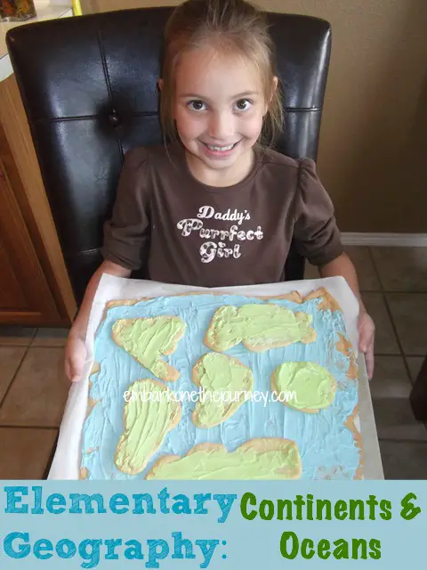
- Make a cookie dough map. See below.
Continents and Oceans Cookie-Dough Map
We used two chubs of cookie dough, but you could use dough made from scratch. Roll one chub of cookie dough flat. Bake it according to the directions on the package. Ice it blue. This will be your oceans.
Roll the other chub of dough flat and cut out (the best you can) the shapes of the continents. Bake them according to the directions on the package. Ice them green and/or brown. Place the continents on your map base (oceans).
Additional Resources You May Enjoy
What is your favorite activity for teaching your little ones about the continents and oceans?


![Oct.Emma_LabeledWallMap[4]](https://embarkonthejourney.com/wp-content/uploads/2015/02/Oct.Emma_LabeledWallMap4.jpg)
![DSCF4046[7]](https://embarkonthejourney.com/wp-content/uploads/2015/02/DSCF40467.jpg)

I’m totally loving the cookie dough map. How awesome is that?!
This is a great homeschooling unit! I’m saving this to my Deliberate HOMESCHOOLING board.
Wishing you a lovely day.
xoxo
I Love this! Great tips. You are creative. Thanks for sharing.
Thank you!
Thanks, Jennifer! We did have so much fun with this unit.
I love your cookie map!
Hi, Tara! Thank you for blogging about geography. I have an 8th, 5th, and 2nd grader. Do you have a suggestion for a wonderful geography curriculum that doesn’t use a “dry” text book? I’m looking for something hands-on and fun. Thank you so much for your wonderful blog!! I enjoy reading it. You are so helpful and encourage us new homeschooling moms. I wish you and your precious family a wonderful day!!! Take care, Leanne
Thank you for your kind words. We used Galloping the Globe in the lower grades. It’s definitely not dry, and it’s very hands-on. It would definitely work for your younger two, and I doubt it would be hard to “beef it up” for your oldest.
Thanks! That was such a fun project.